News
News - News
| 25.01.2023 | NEW publication: The land–atmosphere feedback observatory: a new observational approach for characterizing land–atmosphere feedback Key Points: > Land-Atmosphere Feedback Observatory (LAFO) has been installed and allows comprehensive and high-resolution measurements in the the soil and land surface, vegetation and lower atmosphere > The sensor synergy contains lidar systems, eddy covariance stations, a soil water and temperature network and vegetation monitoring > Observations are organized into operational measurements and intensive observation periods (IOPs) > LAFO will provide new insight into exchange processes and their statistics for improving the representation of L–A feedbacks in climate and numerical weather prediction models Späth, F., Rajtschan, V., Weber, T. K. D., Morandage, S., Lange, D., Abbas, S. S., Behrendt, A., Ingwersen, J., Streck, T., and Wulfmeyer, V. (2023): The land-atmosphere feedback observatory: a new observational approach for characterizing land-atmosphere feedback, Geosci. Instrum. Method. Data Syst., 12, 25–44, https://doi.org/10.5194/gi-12-25-2023 |
|---|---|
| 01.12.2022 | Open position in LAFO! We seek for a postdoc, starting on Feb 1, 2023, in order to perform research studies on land atmosphere interactions using scanning, high-resolution water vapor and temperatur lidar systems. More information here: job offer |
| 22.11.2022 | NEW publication: Estimation of the Surface Fluxes for Heat and Momentum in Unstable Conditions with Machine Learning and Similarity Approaches for the LAFE Data Set Key Points: > The LAFE Data Set is used to study relationships between surface fluxes and variables of the land–atmosphere system aby means of two machine learning (ML) techniques. > The ML approaches outperform MOST and BRN. > The results imply that further studies of surface fluxes and other turbulent variables with ML techniques provide great promise for deriving advanced flux parameterizations and their implementation in land–atmosphere system models. Wulfmeyer, V., Pineda, J.M.V., Otte, S., Karlbauer, M., Butz, M.V., Lee, T.R. and Rajtschan, V. (2022) Estimation of the Surface Fluxes for Heat and Momentum in Unstable Conditions with Machine Learning and Similarity Approaches for the LAFE Data Set. Boundary-Layer Meteorol. https://doi.org/10.1007/s10546-022-00761-2 |
| 11.10.2022 | Dr. Tobias Weber has been accepted into the SoilWat Initiative. The GEWEX-ISMC* SoilWat Initiative brings together two research communities to improve the representation of soil and subsurface processes in climate models. The soil and groundwater research community and the climate modeling community (the latter represented by GEWEX) are collaborating to identify the most pressing challenges and issues related to this effort. Hohenheim researcher Dr. Tobias K.D. Weber from the Institute of Soil Science and Land Evaluation joined the SoilWat initiative in October 2022. *ISCM - International Soil Modelling Consortium *GEWEX - Global Energy and Water Exchanges Project of WCRP Link to SoilWat Initiative |
| 01.10.2022 | WaLiNeAs has started Extreme heavy precipitation events (HPEs) pose a threat to human life but remain difficult to predict because of the lack of adequate high frequency and high-resolution water vapor (WV) observations in the low troposphere (below 3 km). The Water vapor Lidar Network Assimilation (WaLiNeAs) project will deploy a network of 6 autonomous Raman WV lidars around the Western Mediterranean to provide measurements with high vertical resolution and accuracy to be assimilated in the French Application of Research to Operations at Mesoscale (AROME-France) model, using a four-dimensional ensemble-variational approach with 15-min updates. The Institute of Physics and Meteorology of University of Hohenheim operate their water vapor Raman lidar ARTHUS on the island Corsica and provides a humidity profile every 15 minutes for data assimilation. More details in Falment et al. (2021), doi: 10.1007/s42865-021-00037-6 |
| 18.07.2022 | ECSS exkursion to LAFO As part of the MMDA lecture (Measurements, Modeling, Data Assimilation), students of the Hohenheim Master's program "Earth and Climate System Science" visit LAFO. The students got an insight into the LAFO concept and the measurement instruments. They visited an eddy covariance station and a WaTSeN station as examples of measurements of moisture, temperature and energy fluxes in the soil and at the land surface and learned how the influence of different crops is investigated. The special feature at LAFO is the simultaneous measurements in the atmosphere by lidar remote sensing systems. 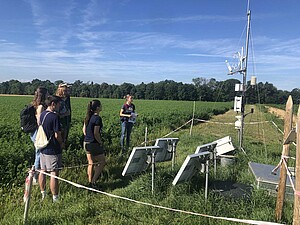 Visit to an EC and WaTSeN station. All individual sensors are presented and their synergy was explained. |
| 01.04.2022 | WaTSeN stations supplemented by nesting aids As part of research on insect diversity in agricultural landscapes, standardized surveys of the species diversity of solitary wild bees, solitary wasps and their parasitoids will be carried out in 12 study landscapes from March to October 2022. For this purpose, nesting boxes will be deployed, which will be colonized by the study species over the course of the year, A few of them are placed next to WaTSeN stations (see figure). The aim of the studies is to gain a better understanding of the role of landscape composition and configuration for biodiversity conservation. more details about the research work here in the pdf... 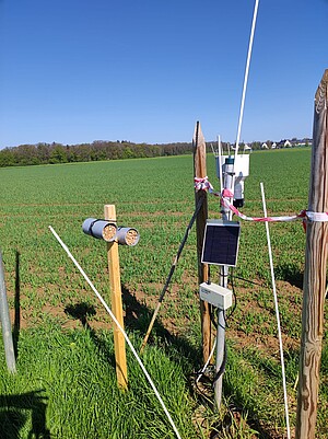 A wild bee hotel (left) at a WaTSeN station (right). |
| 01.03.2022 | NEW Publication: Simultaneous Observations of Surface Layer Profiles of Humidity, Temperature, and Wind Using Scanning Lidar Instruments Key Points: > Surface layer (SL) profiles observed simultaneously with scanning Doppler, water vapor differential absorption and temperature rotational Raman lidar > Comparison of Monin-Obukhov similarity theory profiles with lidar profiles > Demonstration of method to estimate friction velocity and latent and sensible surface heat fluxes from fits to the SL profiles Späth, F., Behrendt, A., Brewer, W. A., Lange, D., Senff, C., Turner, D. D., et al. (2022). Simultaneous observations of surface layer profiles of humidity, temperature, and wind using scanning lidar instruments. Journal of Geophysical Research: Atmospheres, 127, e2021JD035697. https://doi.org/10.1029/2021JD035697 |